I thought (if you are as Bonkers as we are) that you might be interested in this map of the European watersheds – the original and some better information is on Wikipedia here.
Basically once we get quite close to Linz we will move from a place where a raindrop will end up in the North Sea, to a place where the next raindrop will end up in the Black Sea.
We’ve been in the Rhine and Elbe watersheds and we are now moving into the huge Danube region which goes almost all the way to Turkey. It’s kinda interesting if you are a bit of a geek about these things.
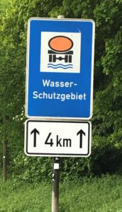
 Which reminds me of this extremely mysterious sign that appears all across Germany, often in this coloured version to really bring the point home to you… that you are now entering a Wasser-Schutzgebiet. Using my mythical (rather than legendary) language skills, and a copy of Google Translate, I can tell you that you are now in a “water-reserve”. But the sign remains uninformative. What is the tanker doing driving over the water? What are you supposed to do, or not do, in such a place? (Mifter Bat you are almost certainly not supposed to make pee pee behind the trees.)
