Doris suddenly realises that the UK is not square, and it is not triangular.
As we drive North we have the road atlas open. From page 14 where Bishop’s Stortford is proudly centre page, through page 45 where Hexham is featured – once the UK has Wales on one side and East Anglia on the other it takes quite a few pages to cover the country from West to East, we are on to a country just 4 pages wide once we are in Scotland. Thurso and Orkney are crammed into the final page 56.
In the UK we take it for granted that road atlases start in Land’s End and proceed eastward and then northward to finish in John O’Groats. By contrast, all my European atlases start with page 1 in the north-east corner and work their way downwards to the south-west.
There is some sort of moral there, and I will come back and re-edit this page once I have worked out what it is.
Meanwhile we muse on the Shipping Forecast. With its soothing assurances of “Rain. Good.” it makes ideal background noise for going to sleep at 00:48 or trying to go back to sleep at 05:20. Nobody really knows or cares where North Utsire is, or why Dogger so often has the same weather as German Bight. When Sid and Doris owned Eric The Boat, they were very interested in sea area Wight. Now they live nearer the East coast they should really be listening to Thames, but in fact they are normally asleep before the forecast gets anywhere near that.
Anyway, for your delight and delectation gentle reader(s), here is the link to the Met Office’s current forecast: Shipping forecast and gale warnings – Met Officewww.metoffice.gov.uk › weather › coast-and-sea › ship… and it also features a handy little roll-over map.
And even better, here is the link to the Radio 4 read-out version: https://www.bbc.co.uk/programmes/b006qfvv The headings of “wind”, “sea state”, “weather” and “visibility” are not read out, which is what gives it that poetic soothing flow. “Sole. Northwest, backing west for a time, 4 to 6. Moderate occasionally rough. Showers. Good.” is an excerpt from today’s forecast as I type this. Zzzz. Oh excuse me I must have nodded off.
The Not The Thistle Tour involves no fewer than eight ferries, many of which are going to cross areas which regularly feature in the list of Gale Warnings that open the forecast. And actually the Shipping Forecast does give useful information about wind speed and direction which doesn’t usually feature on the domestic weather forecasts. Interestingly it doesn’t give any information about temperature because a) the direction and speed of the wind will dictate that and b) it is always safe to assume that it is pretty cold at sea round the UK.
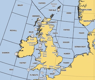 We really do need to work out how this thing works. The list of areas starts with Viking, which is somewhere in the middle of nowhere at about 1:30 on the UK clock. The areas of interest to Sid and Doris will be:
Forth: the area round Dundee
Cromarty: the area round Inverness
FairIsle: the crossing to and from Orkney
Hebrides: the crossing to Lewis, down through the Outer Hebrides and back from Barra, also Mull.
Malin: the area down to Dumfries.
Well I expect that is more than you wanted to know about the Shipping Forecast. Tomorrow’s prize will be the Inshore Waters Forecast.