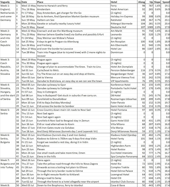
As we continue to crouch round the PC trying to plan Phase 2 with spreadsheets of road/climb distance, ferry timings, hotel availability, we are looking back to Phase 1 and what actually happened to the route.
Two main things :
1. We found that 100km a day and 1,000m of up was quite enough, and in fact shouldn’t be repeated day to day.
2. We bought the Danube Cycleway books in Vienna (shameless plug again for Freytag & Berndt, go there, buy maps from them, or just send them money anyway) which gave us a defined, if sometimes a bit bizarre/challenging/wiggly, route from Austria to Bulgaria. So this was good but it slowed progress and made us a bit lazy on the route planning.
3. In Serbia, Bulgaria and Turkey we were in areas that had actually very few roads and where the e-maps are prone to invent extra roads, so we had to stick to some very main roads. We are still not sure if we should believe the e-maps going forward… and we have completely failed to find paper maps of Turkey or Greece. Looking at other cyclists’ blogs in Turkey, cycling on the “shoulder” of main roads is completely acceptable, it’s not the same as the UK “hard shoulder” rules, so maybe we should be more confident about cycling down main roads in future. Really??!!
Here’s the Phase 1 route. Doris will try to do some bubble charts of stats to see if our decline in strength/stamina is real or imaginary…

Beautiful spreadsheet! Can't wait to see the charts <3